Allied commanders also put into place things that they had learned from two previous failures: one in France and one in England. The planned invasion of Dieppe and the mock invasion of southwest England resulted in many lives lost but also gave the Allied command valuable information to use in planning the Normandy invasion. Allied planners considered four sites in France for what became the D-Day landings. One was Brittany, a peninsula with historic ties to England. The problem with Brittany, invasion organizers thought, was the same as with another potential landing site, the Cotentin Peninsula: It would be too easy for the attacking forces to be constrained into a narrow isthmus, thereby nullifying numerical superiority that the Allied forces had. Even though the port of Cherbourg (the largest element on the Cotentin Peninsula) was a target for Allied occupation, the idea of landing on that peninsula to start with was ultimately rejected. A third potential landing location was at Pas-de-Calais. This was actually the closest point to southeast England and, as such, was a very attractive target. Knowing this, the German forces had heavily reinforced the area. The last landing location considered, and the one finally chosen, was Normandy and not only by process of elimination. Allied planners could have gone back to the drawing board to find another option, but the Normandy area had enough to satisfy most of the people planning the invasion. For a start, the beaches at Normandy were conducive to allowing large numbers of troops onshore at once. As well, reconnaissance missions in recent months had reported that some of the defenses in this part of the Atlantic Wall had weakened since they were constructed. Normandy was close enough to Cherbourg that it could be reached by both land and sea, once a beachhead had been established. Normandy opened out into the wider interior of France, with none of the isthmus troubles presented by Brittany and the Cotentin Peninsula and all of the promise of a sustained attack into central Europe. Intelligence

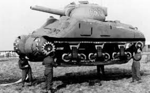
As well, the Allies had carried out an elaborate ruse aimed at convincing the German high command that an invasion was imminent not at Normandy but somewhere else. Known as Operation Fortitude, this multi-dimensional series of events involved a misdirection that had German forces thinking that attacks on both Pas-de-Calais and Norway were imminent. The port city of Calais was the closest to Dover, in southeast England, so it was logical to assume that any invasion coming from Dover would take the path of least water resistance; as well, fighter planes could launch from England and be able to strike positions in and around Calais. The Allied intelligence efforts had sold the tale of the Calais invasion by letting it be known that the dynamic American general George Patton, whom the Germans feared the most, was to be leading the attack. Another story was that a large number of British troops were training at Edinburgh Castle, with an eye toward launching an invasion of the sparsely defended Norway. Double agents let their German contacts know that an invasion was Normandy was probably part of the planning but that it was a diversion, not the main event. Next page > Putting Plans into Action > Page 1, 2, 3, 4, 5 |
|
Social Studies for Kids
copyright 2002–2026
David White


