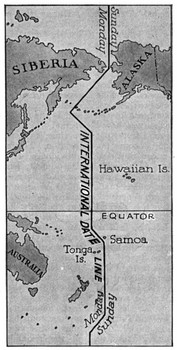
The International Date Line
The International Date Line is an imaginary line that shows where the beginning of one day and the end of another come together. The Line is drawn vertically on maps and runs between the eastern tip of Russia and the western tip of Alaska, then down to the west of Hawaii, then down to the east of New Zealand, and so on. It has several zigzags in it, too. It goes through no land except Antarctica.
So, if you board a plane in Juneau, Alaska, on Monday and fly west to Tokyo, Japan, you will arrive on Tuesday. Why? Because Earth is round. This peculiar effect was first recorded by Antonio Pigafetta, who chronicled the first voyage around the world, begun by Ferdinand Magellan, and later confirmed by sailors accompanying Sir Francis Drake on his round-the-world voyage. Many years went by before someone proposed a Date Line, opposite the Prime Meridian. It began to be drawn on maps as early as the 17th Century was not popularly adopted until much later. Even today, no law proclaims that an International Date Line exists. Still, most globes and maps of the world include it. |
|
Social Studies for Kids
copyright 2002–2024
David White


 Points
near the Line are almost 24 hours apart. When it is Tuesday
in New Zealand, it is Monday in Hawaii. This is because the
globe is divided into Time Zones that total 24 hours.

