The Mercator Projection
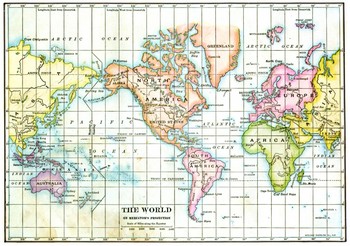
The Mercator Projection was one of the first important maps created by Europeans. It was produced by Gerard Mercator, a Flemish mapmaker who lent his name to his famous work. On such a map, the east-west and north-south lines are straight lines. Because the world is round, this makes for some not-so-accurate geographical representations. Antarctica and Greenland, in particular, look far larger on a Mercator Projection than they are in real life. However, the Mercator Projection does solve one of the basic problems of navigation: how to chart angles. By this time sailors had generally accepted the idea that the world was round, not flat. Yet maps were drawn on flat surfaces. Mercator's map has straight lines, which sailors can use to draw angles. The Mercator Projection also shows the entire globe on one sheet of paper, a novelty when the Projection was introduced. Look at the map below. Say that you want to sail from Brazil, from the easternmost tip of South America, to Senegal, the westernmost tip of Africa. Using a Mercator Projection and its grids, you can draw a straight line from Point A to Point B, figure out the angle of that line, set your compass on the number of degrees that you came up with, and set sail, confident in the knowledge that if you stayed on course, you would eventually reach your destination. Nowadays, we have computers to do this for us; back then, sailors had only their compasses and their sailing smarts. For them, the Mercator Projection was a revelation.
|
|


Social Studies for Kids
copyright 2002–2024
David White