The Zuiderzee Works
The Zuiderzee Works is a massive system of water retention and land reclamation, the most extensive hydraulic engineering project of the 20th Century in the Netherlands. Large amounts of what is the Netherlands is and has been below sea level. Flooding of farmland and living space was all too common for most of the history of the Dutch people, who employed a variety of strategies to try to recover and then stay one step ahead. Among the earliest creations were dikes and artificial hills known as terps. The Dutch used a combination of the two to crate areas of reclaimed land called polders and used windmills to power pumps to keep the water away. 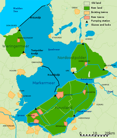
The Zuiderzee is a huge North Sea inlet that routinely claimed land even as the Dutch reclaimed land elsewhere. The Zuiderzee made an inviting target for a giant enclosure project. Civil engineer Cornelis Lely and a team of researchers recommended that the government do just that. They found support among the rich and powerful, including Queen Wilhelmina, who in her 1913 throne speech publicly gave her approval for the venture. Later that same year, Lely gained the position of Minister of Transport and Public Works. He had proposed enclosing the Zuiderzee as early as 1891 and so was very familiar with the plans, projects, manpower, and money that would be required to complete such a large project. It took time for such a major initiative to get the necessary approval. A large flood in January 1916 helped illustrate Lely's point that the Zuiderzee needed to be contained. It took another two years, but the States-General passed the Zuiderzee Act on June 14, 1918. Once the chaos of World War I had subsided, the government was free to get on with the project. The Zuiderzee Works Department began in May 1919. One of its first major decisions was to start by building a smaller dam, across the Amsteldiep. The dam, measuring 1.5 miles, started in 1920 and finished four years later. In 1927, work accelerated, with the launching of construction on the 15-mile-long Afsluitdijk, an enclosure dam. It was nearly 300 feet wide as well, and it was finished six years later, using a combination of till (or boulder clay) and sand. The result was the creation of two calm bodies of water, the Ijsselmeer and the Markermeer. A last step was the addition of a road on top of the dam. 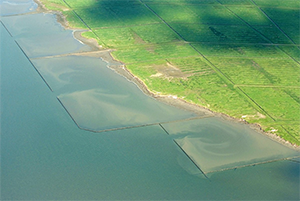
Next came the introduction of new land, through the use of a number of polders with dikes keeping the water out of the new land. Construction of the first, Wieringermeer, finished in 1930. Work on another, the Noordoostpolder, dragged on past the start of World War II, during which resistance fighters hid out in the polder, and finished in 1942. The other two were the Eastern Flevoland (finished in 1957) and the Southern Flevoland (finished in 1967). Helping the polders remain viable were a number of pumping stations, a system of drainage canals, and a network of underground drainage tubes. People used the vast majority of the reclaimed land for agriculture; other uses included housing, infrastructure, and natural reserves. In all, the Zuiderzee Works reclaimed more than 600 square miles. |
|


Social Studies for Kids
copyright 2002–2026
David White