The Wilderness Road
The Wilderness Road was a major route of travel for American settlers heading west for several decades in the late 18th and early 19th Centuries. The Wilderness Road began at the (inland) settlement of Roanoke in Virginia and stretched through the famous Cumberland Gap through the Appalachian Mountains into what is now Lexington, Ky. 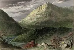
One of only three passes through the imposing Appalachian chain, the Cumberland Gap was the product of natural forces during a period of centuries and was used by animals and Native Americans, Cherokee and Shawnee among them, long before English settlers arrived. Native Americans referred to the pathway through the mountains as Athowominee, one English translation of which is "Path of the Armed Ones." As more and more people from England settled in to the North American colonies, they sought more and more opportunities to seek out new lands; in most cases, this meant heading west. 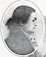
Leading the first known explorers from what is now the United States through the Cumberland Gap was Dr. Thomas Walker a physician who had a knack for finding his way in the wild. Walker had heard stories of the Gap from Native Americans who lived nearby. Walker's party went through the Gap in 1750. The Cumberland Gap was not much more than a footpath when Walker's party went through it. The V-shaped Gap was certainly not fit for travel by goods-laden wagons.
In 1775, the famed explorer Daniel Boone, who had first gone through the area six years earlier, led a party of woodsmen through the Gap, blazing what came to be called Boone's Road. They were in the employ of the Transylvania Company. Boone and his party of 30 ax-wielding trailblazers left what is now Kingsport, Tenn., on March 10. They went through Moccasin Gap in the Clinch Mountains, crossed the Clinch River and 
Travel to Kentucky and the Ohio Valley greatly increased. From 1775 to 1810, more than 200,000 people traversed the Wilderness Road. Once Kentucky became a statein 1792, improvements to the Wilderness Road included widening it so that wagons could travel through. The Road became a toll venture as well. 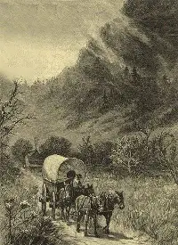
Once it was possible to drive wagons through the Gap, enterprising merchants loaded up wagons full of goods west, to facilitate commerce on the other side. Going the other way were settlers from Kentucky, driving cattle and horses back east for sale. The advent of the National Road in the 1830s made the Wilderness Road less of a first choice for settlers heading west. As well, the construction of the Erie Canal had given merchants another avenue for shipping goods to and from the Ohio Valley. The Wilderness Road was largely abandoned by 1850. Interest in the Road–the Cumberland Gap in particular, peaked again during the Civil War, as Union and Confederate troops seized the Gap in turn; the Union occupation in 1863 was the last of the war. Replacing the Wilderness Road in 1926 was the Dixie Highway, also known as U.S. Route 25. |
|


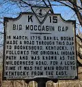 Powell Mountain, and stopped at Martin's Station, a settlement that Joseph Martin had founded in 1769 but had abandoned after an attack by Native Americans. Boone and his party were set on by hostile Native Americans as well, and some of Boone's men died in the attack. The survivors pressed on, navigated the Cumberland Gap, and then arrived in what is now Kentucky, a few weeks after they set out. Boone and his men established a settlement, later named Boonesborough.

Social Studies for Kids
copyright 2002–2024
David White